Thursday, April 27, 2006

Lake Atitlan, GUATEMALA

SCROLL DOWN TO PREVIOUS POSTINGS AND SEE SOME PICTURES

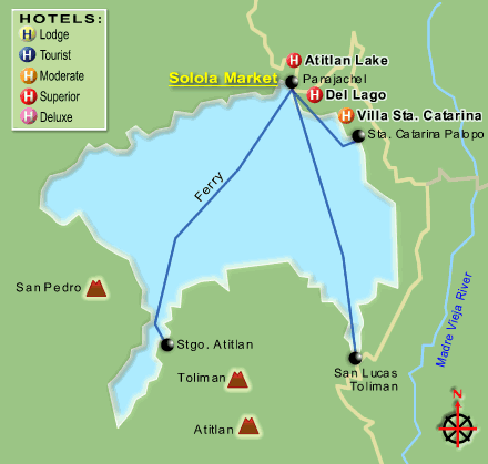
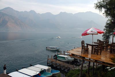
I´m staying in the Mayan village of San Pedro de Atitlan (see map) right on the shores of this magnificent lake, surrounded by three spectacular volcanoes - Toliman, Atitlan, and San Pedro.

Spent most of yesterday at the nearby village of Santiago de Atitlan (35 minutes by boat) . As it was market day, the village was bustling with activity - buyers and sellers, onlookers and me, capturing as many images as I possibly could but trying not to interfere with these people´s activities. Very colourful indeed as these Mayan villagers are all wearing the same clothes to distinguish them from the other villages. I´d say about 99% of women and 40% of men are wearing their village clothes. Especially on market days, only the cleanest and newest village clothes are worn. Its a bit of a ¨show-off¨ day for these people. I find the people incredibly friendly, and even though my camera is often intruding, they still smile and greet me back with a friendly ¨buenos dias¨. Kids, as everywhere, are very intrigued with my camera and I´m more than willing to take pics and show them their own images, which is usually followed by a big smile!

The villagers living around the lake mostly speak their own indigenous languages including Quiche, kakchiquel and Tz´utujil). Spanish is not widely spoken.

Bought half a ton of ripe mangoes...which reminds me....I better go eat them! Also bought an embroidered cloth from an old lady with three prominent teeth, and a very wrinkled face. I really only bought it to make her day....and, with her permission, took a few great pics. What a face...it tells a lifetime of stories by just looking at her.

Did I say I love this place and its people.....its an awesome experience to be here. With my nice room, hammock outside, lawn garden, overlooking the lake from far above on a cliff...for only US$2.4 per night - I could stay here for a long time. A big chicken dinner at US$4....what more do you want!

Adios from Lago Atitlan - Guatemala.

Monday, April 24, 2006

Copan Ruins, HONDURAS

I'm in the small village near the famous Mayan ruins of Copan, in north western Honduras (a six hour drive by minivan from Antigua, Guatemala). It was in AD 628 that Copan began to develop when King Smoke Imix (Smoke Jaguar) came to the throne. The first recorded discovery of the ruins was on March 8th, 1576. Today it is one of the most significant Mayan ruins in all of Latin America...and that's why I'm here!

Spent several hours around the ruins which is quite impressive. As you walk around, you gaze at these ancient structures and you can only imagine (or maybe not really) what this bee nest of a city (20,000 people at its peak) would have been like at that time. It was eventually deserted after the inhabitants cleared the surrounding forests, which resulted in land slides and soil erosion and eventually no crops, no food, starvation, and the entire civilization of Copan came to an end. Those who didn't die, left the area for good. The city was abandoned, taken over by newly grown jungle, and only centuries later re-discovered and unearthed.

The nearby little village where I am staying has small houses, cobbled streets, friendly people, and nice little restaurants. About 60% of all the men are wearing white cowboy hats, and several walk with a long machete hanging by their side. I've seen a few with small guns, but nothing beats the preparedness of the bank and store security guys with their big machine guns. As is common across Central America, most (if not all banks) and many stores have a heavily armed security guy(s) at the entrance.

I kinda like this little town! Lots of green around, clean streets, and birds everywhere!

Next stop (7 hours from here) will be Lake Atitlan, Guatemala, to spend 2-3 days in Mayan villages right by the shores of this beautiful lake surrounded by volcanoes.

Sunday, April 23, 2006

Antigua, GUATEMALA

Nestled between three volcanoes (two of which are active ...of which one I will climb to the crater) Antigua is a quaint colonial town with cobbled streets and pastel coloured houses. Founded in 1543, it was almost entirely destroyed in 1773 by a catastrophic earthquake. Rebuilt from the ruins and ashes, it is now one of the most beautiful colonial towns in Latin America. I still think Cartagena in Colombia is superior...probably because its not nearly as touristy as Antigua...as most travelers are afraid to do Colombia.

The next few days will be hectic. My current plan is to travel to the Mayan ruins of Copan (Honduras), for two days, leaving at 4am tomorrow morning. Then back to Antigua and then to the picturesque lake of Atitlan and the surrounding Mayan villages. Sunday will be to the town of Chichicastenango for the big market. Then likely up north by bus and by boat along the Caribbean coast to southern Belize. Back to Antigua and on May 4th or 5th I should cross into southern Chiapas, Mexico.

Adios!

Friday, April 21, 2006

Guatemala City, GUATEMALA

Similar to Nicaragua and El Salvador, Guatemala has a horrible recent past. In 1996 a peace accord was signed which ended the 36-year civil war which killed an estimated 200,000 Guatemalans (and thousands "disappeared") and left millions homeless, many who seeked refuge in nearby Mexico.

Guatemala City is the largest metro area in all of Central America and suffer from the same illnesses of most Central American cities. Big time poverty, small elite and middle class, buses which blow thick clouds of black smoke into your face, and a bee nest of activity around the local traditional markets. Even so, Guat City has some pleasant areas with classy shopping malls, and quaint streets with romantic restaurants and bars. The Parque Central (Central Park) has the flamboyant Palacio Nacional to the north and an impressive Cathedral on the east side.

I had a good time in the city over the weekend as its nightlife and restaurants are only second best to Costa Rica's capital, San Jose. In line with the rest of Central America, the people are truly friendly and helpful. On Sunday morning up to the old colonial town of Antigua.

Thursday, April 20, 2006

Suchitoto and La Libertad area, EL SALVADOR

SCROLL DOWN TO PREVIOUS POSTINGS AND SEE SOME PICTURES

Last night I saw the "other side" of San Salvador....where the city´s elite hangs out. I was pleasantly surprised to see an almost different world than the rest of San Salvador I have seen so far. Brand new shopping malls (which would be of AAA rating) with wide boulevards connecting upscale residential areas where security walls and camouflaged men with huge assault rifles stand guard! This is the new San Salvador, which was built after the end of the civil war and also since the latest devastating earthquake. This truly is a world away from the poverty I have seen elsewhere in this country. Like in so many other countries, the gap between the rich and poor is wide - very wide. In San Salvador it is probably wider than anywhere else I have seen...except maybe for India. You somehow understand why the masses started with their protests in the 70´s (in 1980 organized in the FMNL guerrillas) against the 14 coffee-growers´ elite families ruling the nation -- which was ignited by the Reagan administration´s armed support of the elite (and the Government´s ARENA party) and the long civil war extended all too long.

I went outside San Salvador in search of the typical Salvadorian lifestyle in the hope of finding a better world than in the city. Spent a day in the hill-town of Suchitoto, billed as the town similar to Antigua and Granada before the tourists arrived. Well....sure there were no tourists in Suchitoto, but was I impressed with the town...NOT. So I decided if the north was no good, I´ll try the south...the Pacific Coast and the port town of La Libertad and nearby beach villages. Though the small beach towns were probably better than anywhere else I have seen in El Salvador, was I impressed...NOT. With several "private" beaches (belonging to establishments catering to the elite), I was limited to where I could go.

It seems that the Salvadorian people just love to live in their own garbage. The garbage seems to be everywhere which is a real sore in the eye. It´s so common to see people, of all generations, to throw garbage out of the bus windows - no wonder the buses are so clean inside! Poverty is NO excuse for disrespect to others and nature!

Talking with some locals recalling life during the civil war and several devastating earthquakes, makes me realize again that these people have gone through a lot in just a short time.

I must admit that my evaluation is based on the little I have seen of El Salvador. I may change my views if I were to see other regions.

For me personally, the friendliness of the Salvadorian people is outweighed by the garbage. In conclusion, I am glad to leave El Salvador tomorrow and head north to Guatemala. I´ll return one day to El Salvador when these people have learnt to place garbage where it belongs! Adios!

Tuesday, April 18, 2006

San Salvador, EL SALVADOR

At 11:37 am on 13th January 2001, a series of earthquakes rumbled through San Salvador which caused major destruction and killed at least 1,246 people in the San Salvador area and left more than 8000 people injured. Some of these quakes also caused destruction in nearby Guatemala City and around Nicaragua.

The 12-year long civil war which raged in El Salvador from 1980 to 1992 was fueled by U.S. aid to the Salvadoran military with the aim of crushing the local opposition. The government harshly repressed dissents, and at least 70,000 people lost their lives in killings and bombing raids waged against civilians throughout the countryside.

The impact of the earthquakes and civil war in El Salvador is evident around the city and its infrastructure is still crumbled after all these years.

Nevertheless....San Salvador is an interesting mesh of buyers and sellers and hawkers and stalkers! I don't particularly feel safe in most areas but its great to experience the Salvadorian vibe. Very few tourists (or any Westerners) around - at least in the "el centro" area.

Tomorrow I am heading north to the village of Sochitoto and hope to find some mountain tranquility!

Monday, April 17, 2006

Managua, NICARAGUA

I have little comment about Managua.

In fact, I think of it as a wasteland, windswept, "sick-dog" city...and forgive me to be so brutally blunt. Proverty is a real serious problem here!

The city was damaged several times by huge fires, and almost destoyed in the December 23, 1972 earthquake which left 10,000 people dead and thousands without homes. Yet, almost 2 million people still call it home. The downtown area was totally wiped out in the 1972 earthquake and even today, little has been rebuilt. When international help came in to rebuild the town, the dictator Anastasio Somoza Debayle (President at that time) and his troops allegedly took the donations and either hid them from the public or used the donations for themselves. The old cathedral is still closed with huge cracks in its walls. Most rubble of the ruins have been removed but most street blocks are still vacant....which became playgrounds and baseball fields. Some just garbage dumbs...most...just empty. Like so many places in Central/South America (with the exception of Costa Rica and some others), the people throw garbage everywhere -- seems like they love living in garbage! What a shame! The general rule in buses are: Dont litter the bus...throw it out of the window.

Off to Honduras tomorrow and then on to San Salvador, capital of El Salvador.

Thursday, April 13, 2006

Photos of Costa Rica!

On popular demand from my blog readers....here are a few pics I took in Costa Rica.

Two-toed sloth (Cahuita National Park, Costa Rica)

Three-toed sloth (Manzanillo Refuge, Costa Rica)

Tapir (Corcovado National Park, Costa Rica)

Scarlet Macaws (Corcovado National Park, Costa Rica)

Wednesday, April 12, 2006

Granada, NICARAGUA

Granada.....another beautiful old colonial town where just wandering through the streets is a real treat for me. Spent the past 5 nights here in this little town on the north shores of the mighty Lake Nicaragua. From here I have a view of Volcano Conception, on Ometepe Island (in the lake) which I succesfully climbed a few days ago. Every time I lay my eyes on this cone shaped volcano, I still can´t believe that I climbed all the way to the top. From a distance, the summit of the volcano looks real high....and it sure is!!!

Did a few trips around the area. Volcano Masaya, another active volcano north of Granada was worth seeing. The chicken bus ride towards the volcano and the 12km roundtrip hike was eventful. The little village of Masaya, which was almost destroyed in recent earthquakes, is still standing proudly serving as a major market destination for the locals from as far as Granada and Managua. A lazy Sunday along the crystal clear waters of crater filled Lake Apoyo....is just what I needed to conclude my visit to southern Nicaragua. This morning I am off to capital city, Managua, and from there further north into El Salvador.

Monday, April 10, 2006

Ometepe Island, Lake Nicaragua, NICARAGUA

SEE UPDATE BELOW IN RED

Only 7 hours north of San Jose, Costa Rica, and my Tica Bus halted at the town of Rivas, Nicaragua. From here I took a 45 minute ride in a very old squeeky wooden boat (read = scary) to the village of Moyogalpa on the western shores of the Island of Ometepe. This island, located in Lake Nicaragua, is formed by two volcanoes, Conception (active), which rises 4,430 feet above sea level and Maderas (dormant) at 3,833 feet. Conception is regarded as the most perfectly formed volcano cone in Central America, and the highest and most active volcano in Nicaragua.

The old school bus ride to my current base, Altagracia, on the north eastern shores of the island, was excitng to say the least. The views of Volcano Conception and Madeiras were stunning, and the locals live a very basic life. Homes are generally built of mud, dried palms, and palm thatched roofs. Friendly people indeed!

Tomorrow I am scaling the Volcano Conception and hope to catch a blimp of the sulphur vents and constant small explosions inside this active crater. The climb should not take me more than 5 hours up (starting at 5am), and I expect to roll back down...which should be fast!!

I trust to be back safely in my guesthouse tomorrow night!

UPDATED 24 HOURS LATER
I started the climb up Volcano Conception (1,610 meters from the base at sea level) with a Dutch guy, Dutch girl and Swedish guy....and our local guide. At the base of the volcano, the vegetation is mainly banana plantations. As we went up through the bananas plants, we climbed through an area of rain forest, followed by cloud forests (with many flowers and orchids), and then reached the area of smaller bushes around the 1100m level. Then came an area of mud and decomposed ferns (destroyed in a recent eruption) and the last 100 meters was just gravel with no vegetation at all. In this area, we were covered by clouds and the wind was blowing at about 200km per hour right towards the summit of the crater. If it wasn´t for the strong wind, I doubt we would have been able to climb or crawl up the last 100 meters. In this fiercely blowing wind, it was obviously very dangerous to get too close to the crater....so I had to crawl closer to peek inside but due to the cloud cover, visibility was limited. Strong fumes of hot sulphur gasses blew into my face and the small stones around the crater was very hot. As I really didn´t want to push my luck and become a few boiling bones in a sulphur lake (or worse....a lava lake), I retreated. THIS was the most hostile environment I have ever experienced! The sulphur smoke, hot stones, hurricane strength wind, clouds which limited visibility to 7 meters....this must be what a bad day at the summit of Mount Everest must be...except we had no snow and ice. My two fellow climbers (the guys) got separated from us at the summit and we feared they were blown into the crater!! After a long and hellish search (and a few spectacular falls) we found them about 150 meters below the crater rim -- lost in the bushes!

The walk down was not any easier than going up and all of us had several spectacular falls! With no broken bones and deep wounds, we arrived back at Altagracia village.....and drank about all the cold drinks available in town! This, was a great day in my life!

The locals are very friendly...and here on this volcanic island with the two beautifully coned volcanoes (Concepcion and Madeiras), people still live very basic lives. I would guess a family of 4 would live on no more than US$5 per day.

This afternoon I´m taking the ferry to Granada on the north shores of Lake Nicaragua.

Sunday, April 09, 2006

Monteverde Cloud Forests and Volcan Poas, COSTA RICA


With a rented car the 3.5 hours trip to the tiny settlement of Monteverde and Santa Elena on the fringe of the Costa Rican cloud forest was very bumpy on an unpaved road with huge potholes. The last part of the road snaked through beautiful scenery as the road climbed higher and higher towards...the clouds! Spent about 3 hours hiking through the Santa Elena cloud forest. Giant trees are enshrouded in orchids, mosses, bromeliads, and ferns, and in those small areas where sunlight penetrates, brilliantly colored flowers flourish.

The mist covered forest where little sunlight reaches the ground is crawling with life...yet very hard to see for the untrained eye. Last count shows 2,500 plant species, 400 species of birds (including the colourful Quetzal), 500 types of butterflies, and more than 100 different mammals - including many cat species. Indeed an experience to hike through these forests! Costa Rica is known for protecting probably the most beautiful cloud forests in the world.

The day and night hiking was complemented with visits to a nearby serpentarium, orchid farms, etc.

Further south my visit to the active Volcano Poas was a great experience! The water filled crater is surrounded by sulphurous gas vents and geysers. The volcano has a long history of eruptions, going back as much as 11 million years. Last week the eruptions were so violent that access to the viewing area was closed for a few days. Yesterday the water "exploded" 200 meters into the air...and if you were standing at the viewing spot, you sure would have had to run for cover! Its geyser-like eruptions of muddy water and steam, have given it the reputation as the world’s largest geyser.

Further south towards San Jose lies the beautiful waterfalls of La Paz surrounded by some of the most impressive green jungle I have ever seen. A nearby private reserve has a great collection of amphibians, humming birds, flowers, birds, reptiles, and butterflies.

Was great to see the enthusiasm of the local crowd at the Rock Festival on Saturday held in the vicinity of Volcano Poas. Several local and Latin bands entertained a crowd of about three thousand people.

My three weeks in Costa Rica was very eventful! Costa Rica is without a doubt one of the most stunning countries on earth!!

Tomorrow up north to Nicaragua. I trust to sleep in the village of Altagracia on Ometepe Island, in Lake Nicaragua from where I will explore this island formed by two volcanoes (Volcano Concepcion and Volcano Maderas). Then, by ferry to the town of Granada on the north shores of Lake Nicaragua.

Friday, April 07, 2006

Manuel Antonio, COSTA RICA

The Village of Manuel Antonio here towards the south, on the Pacific Coast of Costa Rica, is indeed another piece of paradise. The nearby national park of the same name is the main reason why I took the 5 hour minibus ride from Volcanoe Arenal. Yesterday spent most of the sunny day hiking.....tough hiking....in the dark shades of the jungle...saw quite a few animals but the prize was....a big mamma 3 toed sloth hanging upside down from a branch with her tiny woolley baby clinging to her tummy. What a sight! I have now seen many sloths and had several close encounters...I am a very happy man! On the way to Manuel Antonio we had to stop on the road to wait for a young sloth slowly....so slowly... crossing the road...how vulnerable he looked. Maybe they are just "stupid monkeys" .....nahhhh. Also yesterday in the park got a very close encounter with a White Faced Capuchin Monkey". What a cutie!

I'm heading back north today to the cloud forests of Monte Verde and Santa Elena. Tomorrow south to Volcanoe Poas if open due to major eruptions last week...will also spend several hours at a local Rock Musical Festival in the park...near the volcanoe....to beef up my Costa Rican cultural spirits. Then Sunday back to San Jose and Monday north to Nicaragua.

Adios Amigos!

Tuesday, April 04, 2006

Volcano Arenal, COSTA RICA

I´m at the most active volcano in Costa Rica, Volcan Arenal, in the central north of Costa Rica. I did a night visit to the west side of the volcano and could see sporadic outbursts of lava with huge lava rocks falling down the sides...almost halfway down from the crater. Due to its unpredictability and violent behaviour, nobody is allowed within 3km of the base. What a bummer! I would have loved to get closer! Anyhow, the nighly shows are spectacular. Today cloudy and rainy, so I did a lot of hiking in the forest and visited a really nice waterfall surrounded by cloud forests. Also digitally captured the famous and strange looking Boat-Billed Herons sitting on their nests.

Next stop...the National Park of Manuel-Antonio along the Pacific coast...towards the south.
Adios!

Site Feed Top Travel Blogs Blog Directory & Search engine